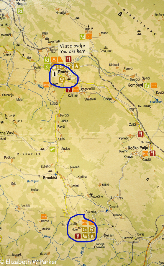
Map of our walk from Roc to Hum.
June 3, Friday
Despite the highlights of this day’s adventures, I had to go back to my pictures to reconstruct the day. Unfortunately, it happens to me at least on one day of every trip, usually just about in the middle. I start to tire of waking up really early to write what happened the day before. I know full well that this may mean that I cannot catch up afterwards. I console myself thinking that perhaps for my readers a bit of fatigue sets in too – so my writing less turns out to be a blessing! I do have pictures though!
This was the day we walked in Istria. Istria is a large peninsula in northwestern Croatia, where the influence is decidedly Italian. If you remember your history, borders in this area changed many times, and over the course of history this land was actually part of Italy. It is also a popular place for Croatian families to own second homes, as the climate is very Mediterranean, hence mild.
We went by van to a town called Roc. Roc (pronounced “roach”) is well-known for its accordion festival. (Go figure!)
Our destination today was Hum, the world’s smallest town. Technically it is not the world’s smallest town according to Wikipedia, but it just goes to show the power of marketing. The population today is 27 people, and it is classified as a town because of the governmental structure, not the size. Watch the slideshow to see the table where the town council meets!
Our walk took us through idyllic countryside with a bit of everything – rolling hills, distant mountains, villages and farms. I was taken by the rustic buildings, the shutters and vines. A funny anecdote: We were being dropped off along our walking route and incurred the wrath of a homeowner who did not like the fact that we had stopped on a public road to unload, right in front of his house. He was probably the only unpleasant person we encountered during the entire trip. Unfortunately, we had no idea what his beef with us was as he was shouting in, I assume, Croatian.
Once we had eaten a delicious lunch (have I yet to describe any of our meals as less?) at the Konoba Hum, (konoba designates a simple eatery), we had to abandon plans to continue walking because of the weather. We did drive the route we would have walked, the way dotted with sculptures of the glagolithic alphabet, one of the historical things that makes this area significant.
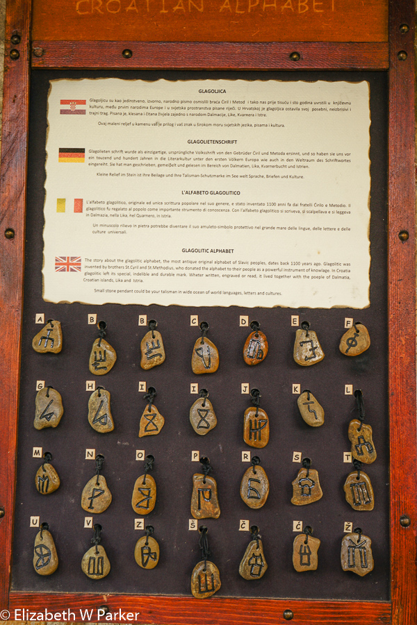
Glagolithic Alphabet
Never heard of a glagolithic alphabet? You’re not alone! You can read the link for more information but basically glagolithic refers a script invented by Saint Cyril (a Byzantine monk) to put contemporary (9th century) Slavic language into writing so that he could spread the gospel to the Slavs. It was only used in Croatia and only for liturgy, but all the way into the 20th century!
On Friday evening, back in Opatija, we walked along the Lungomare, a seaside promenade that goes right along the edge of the rocky shore. We had dinner in Volosko, at an old and very famous fish restaurant, named Plavi Podrum. At dinner outside under the awning, we sampled fish caught fresh that day and as the sun set, admired the bright lights of Rijelke, just a bit farther south.
I stopped to buy a souvenir from some children selling home-made seashell crafts along the walk. Talking to them was lots of fun!

The gulf is so flat and calm in the morning.
June 4, Saturday
This morning our walk took us on a long walk on the Lungomare northward, starting with a stroll through Opatija. Along the way are grand hotels and grand mansions. We walked through the gardens and saw the mansion that started it all, the Villa Angiolina, (built by the wealth Austrian I mentioned earlier). The villa was the beginning of tourism for this town, as friends came to visit and built villas, too. Today Villa Angiolina is the Museum of Tourism, covering both Istria in general and Opatija, specifically.
It is interesting that Opatija, from these origins, has the architecture of Austria (very Viennese!) and not of the Mediterranean!
Walking along the sea, as I mentioned, right at the edge of the rocky shore we passed through towns called Icici (Ee-Chee-Chee) and Iki (Icky) ending up in Lovran where we walked into the small walled historic center and had fresh fish yet again. This time our repast was outdoors at a cute place called Lovranska Vrata.
After lunch, our driver picked us up in the van, and we were on our way to catch a ferry to take us to Rab Island.
We followed what he claimed was one of the 10 Most Scenic Drives in Europe according to the German Touring Club. It was not the easiest to admire as we were driving, the curving road often put the sea to our backs. But a stop along the way revealed a wonderful panorama of the Croatian Islands in the Adriatic. It really was a lovely view. After the stop, however, the drive had a few “exciting” moments (our driver was channeling Mario Andretti) and by the time we reached the ferry, Galina and I were just about completely grey-haired. The men were cool.
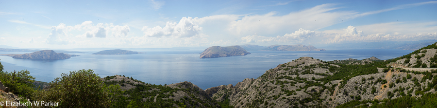
View from the scenic road out into the Kvarner Gulf (or Bay)
We also learned about the Bora (or Bura) wind as we drove. This is a “north” wind that barrels down on the Croatian coastal islands from the Velebit Mountains which run about 140 kilometers along the mainland coast. Though the wind is also present in Slovenia, Montenegro and other countries along the Adriatic it is strongest right in the section we were driving. No wind today – special climatic forces need to be at work to produce the wind – but watch out when it does! The wind is like a hurricane, without the rain, and with the addition of teeth-chattering temperature drops. It can cause the closure of our scenic road– first for motorcycles and double-height vehicles, then for trucks, cars with trailers and buses, but even for regular cars, if the wind is strong enough. How strong can it get? It has been clocked at well over 200 km per hour. And it’s gusty. (You’d have to be gutsy to go out in it!)
As the wind roars down the mountain it strikes the water and blows water and salt spray against the eastern sides of the islands along the coast. This gives the islands a binary personality. The easterly sides are rock and barren of vegetation, and the westerly sides are lush and green. A map of our destination, Rab Island, reveals green and white areas so clearly that you could draw the island elevations in yourself.
Finally at the ferry, we had a 10-minute wait until we drove on, a 15-minute ride and a 5-minute disembarkation, before we were on our way to Rab (town). The village is located in a low area behind a high ridge to the east, so we were in a green belt. The island has many deep narrow bays, and Rab is located in one of the bigger ones. Our hotel, Hotel Arbiana, is located right on the water and our room has a wonderful balcony view that encompasses the small harbor, the island of Dolin, the long barrier part of Rab Island, and beyond, just below a horizon of full clouds, lies the mainland and the Velebit mountains. We had our dinner tonight outside on the patio of the hotel (the restaurant is called Agatini Vrtovi), everything very calm and relaxing.
Keep reading to find out what we did on Rab Island for the following two days…

You must be logged in to post a comment.