
Detail of the 1950s Snapshots Mural (The person who commissioned it wanted women in bathing suits…)
Though the scenic highlight of our workshop week was definitely the caves on Devil’s Island, looking for photo ops we also traveled off island, to Ashland, to shoot the murals.
Odd detail from the Alaph Mural
By no means did we see all the murals, but those we did were quite impressive. [Gerry and I went back on our way to southern Wisconsin and took pictures of those I missed on the first day.]
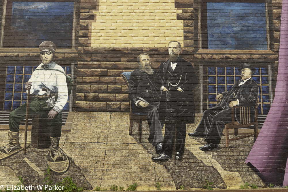
Here is a link to read about the murals. It includes a page about each of the individual murals. Just a couple of interesting facts about the murals in general. These are the work of two women artists, spanning 20 years; the first dedicated in 1998 and the most recent, May of 2018. The people shown in the murals are real people! Most of the images were done from photographs supplied by local families and the Ashland historical archives and, with very few exceptions, the people are identified by name.

Detail of The Women’s Mural
As a tourist to the area, you will enjoy a morning or an afternoon walking around the historic center of Ashland to see the murals. Take along one of the walking guides if, like me, you like a little narration with your art. Assuredly you can enjoy them for their visual impact alone. They are very well done. You do not need to know the individuals pictured and, collectively, they give a sense of the history and the people of Ashland.
To see the slideshow at your own pace, click on the pause button on the screen. The link above allows you to page through in the same order I have presented them here and read all about each one.
[In the Santurce area of San Juan, Puerto Rico, murals have been sought in a festival named “santurce es Ley.” Here is an old post with pictures of those murals.]
“We wrapped up our workshop on Friday, the first day we did not have sunny weather. Part of the wrap-up was a contest. Remember the part in the blog about shooting in the junker? We were tasked with finding a face. There was a $50 prize for the best face upon a vote by the class. Here’s the winning entry. (It is mine. Does this make me a professional photographer?)

The face in the junker
To round out a full week in the area, Gerry and I stayed two extra nights in Bayfield. That gave us a full day on Saturday to explore the mainland parts of the Lake Superior National Lakeshore. We started by visiting the Visitors Center located in Bayfield.
Bayfield was once the county seat and all the administration and courts for the county were located in an imposing brownstone building. The National Park Service now occupies the building. I mention this because the quarrying of brownstone – the very same stone that gives its name to townhouses in big metropolises (we lived in a brownstone in Brooklyn back in the early 80s) – was a big industry in this region.
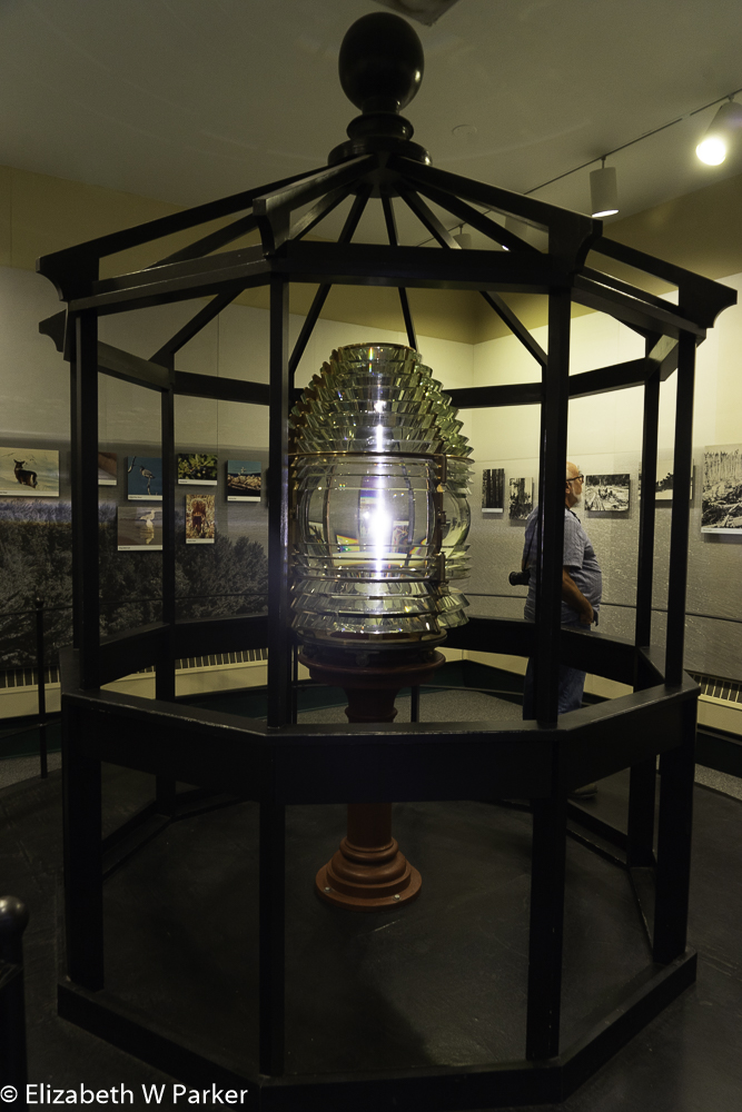
Frenel Lens in the lighthouses exhibit at the Visitors Center in Bayfield.
A glutton for information, I discovered several things at the Visitors Center: First that there are no fewer than 5 NPS properties on Lake Superior. In addition to the two I have already mentioned, Isle Royale and the Apostle Islands, the Service maintains Pictured Rocks National Lakeshore, the Grand Portage National Monument and Keweenah National Historic Site. ( I think a long trip with visits to all 5 … Heck! Why not a circum-ambulation of the entire lake – is in my future. You want to know all about these places and see pictures, right?)
From the Bayfield Visitors Center we got on the road (#13) and drove to Meyer’s Beach, the southwestern corner of the NPS property. We parked and took the trail through the woods to the cave overlook area – a walk of 1.8 miles each way.
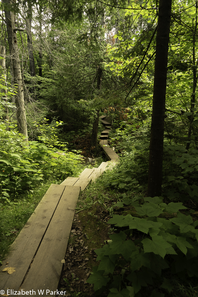
The beginning of the Cave Overlook Trail. Don’t be fooled. the boards were not easy on the legs.
Like going to see the caves in the small, fast, boats, hiking to the overlook was a situation where you have to endure the trip to get the reward. The scenery at the overlook was worth every pain-filled step along a trail that was up and down, up and down, first on wooden stairs (no rails!) and then over roots and through mud.
I so wish the pictures could convey the heart-stopping height of the cliffs, and depth of the caverns carved by the waves. I had to hold on to a tree in order to lean out over the edge to point my camera down, and even so I had to fiddle with all the shadow sliders in Photoshop to make the depths visible in the pictures. With the bright sunlight filtering through the pines, the upper regions were perfectly lit, but the depths were dark and mysterious. Look for the occasional flash of a neon kayak to help you find the water!
The way back was long, and we were already pretty tired. The trail is strenuous for a couple of 60 year olds! At about the midway point, there is an access to the beach. We walked down to the water only to discover that walking back along the beach was going to mean walking in the water. We did it. We took off our shoes and socks so we could wade around the overhanging vegetation. OH! That cold water felt good on our aching feet! Even my cold-phobic husband got used to the temperature, eventually.
The walk along the beach was a breath of fresh air (literally – it was cooler near the water) because the scenery along the shore was totally different from what we had seen in the woods. The beach was sandy with pebbles. The waves were small and gentle. Birches leaned out over the sand to catch the sunlight, their white bark and bright green leaves contrasted merrily against the dark pines, the blue water and high overcast sky. I looked for pretty rocks and beach glass caught against the dried and bleached driftwood.
Exhausted and thirsty by the time we arrived back at the parking lot, we got into our car and headed to Cornucopia, WI for a bite to eat.
Cornucopia is literally a one block town. On one side is Little Nikki’s Bar and the Post Office. On the other a hardware/convenience store. Oh! There is also a real estate office and an ice cream shop. That’s the whole town! We had a very good lunch at Little Nikki’s, so if you are going to hike or kayak from Meyer’s Beach, take note that there is a decent place to eat at about 5 minutes from the parking lot.
Cornucopia is also where you rent kayaks to see the caves. Be mindful that you need a sea kayak on Lake Superior, not a regular recreational kayak!
To fill out the afternoon we drove “back” toward the Sand Bay entrance to the Lakeshore. I say “back” because Meyer’s Beach is at the far southwestern corner of the property, and we were headed backwards towards Bayfield to get to Sand Bay. (We were going north along the western side of the peninsula).
Someplace, I read that the “thing to do” at Sand Bay was see the fishery. Ask and ye shall receive!
The ranger station at Sand Bay is in a trailer while a new Visitors Center is under construction. We stopped at the trailer and asked the ranger on duty about the fishery, and we were offered the free guided tour! Just as we had been told.
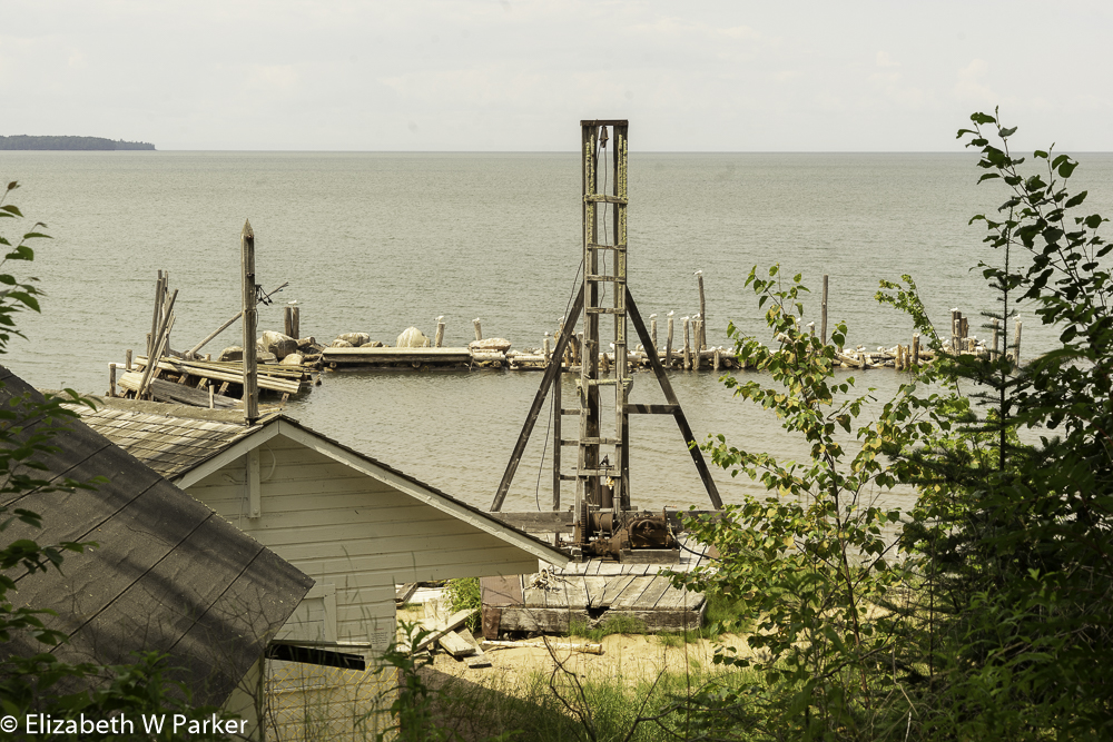
This is the pile driver that was used to put down the pilings that supported the pond nets. Now on shore because of storm damage.
It was extremely interesting. Our guide was a history enthusiast and she enjoyed telling us all about the operations, the fishing in the Lake Superior, the lives of the people in the area at the time – and showing us the buildings, inside and out. Be aware that you do not need to take a guided tour to walk around the fishery property, but you will not be able to go inside.
Actually, this summer, much of the fishery is closed because of storm damage. Lake Superior is infamous for it’s storms. Earlier in the week we had seen storm damage on Devil’s Island that closed the campsite there. Here, at the fishery the damage was impressive (even to someone who went through Hurricane Maria in Puerto Rico last year!)

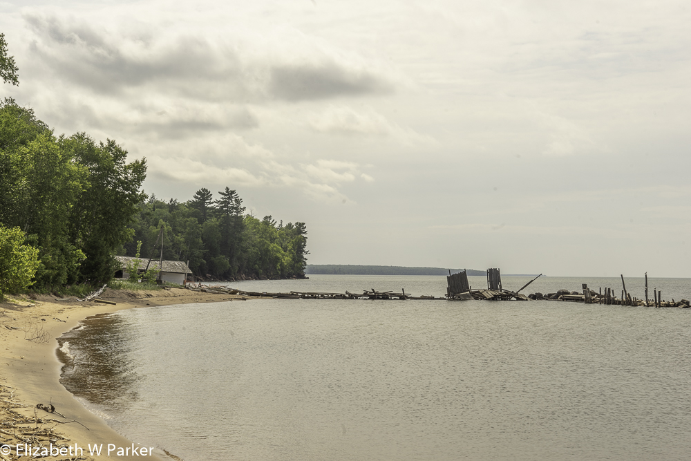
Here you can see the damaged wharf.
The long stone wharf was destroyed, huge pilings that once contained the rocks thrown helter-skelter. The wooden pier was gone. The long shed that served for receiving the fish was so deteriorated by the storm that it had to be removed from the pier to try to preserve it. The ranger explained that the maintenance crews had so much repair work, that they were not able to keep all the parts of the park open this summer.

Rings for the pond nets. These were slipped over the pilings.
We learned a lot. This fishery employed “pond” nets (sometimes written “pound” nets) which kept the fish alive. The nets were emptied about 2-3 times a week, so getting live fish meant fresher fish. The other type of net in use in Lake Superior was a gill net. This is a large flat net situated vertically to lake bottom. The fish swim into it and get caught, their heads through the holes, their gills preventing them from going backwards and their bulk from going further forward. They drown. The gill nets are also not particular about what fish they catch – They catch anything, non-food fish, and npn-fish, too.

Nets and more in the work shed
The pond nets are shaped like a giant basket, in that they have a floor and sides. At the corners or around the edges huge metal rings are attached to the net. These slip over pilings that are driven into the lake bottom, suspending the net in the middle. The fish are guided into the nets. Once the fish swim into the “basket,” they have a hard time finding the exit again.
To haul in the nets, the men maneuver their large flat-bottomed boat around the edges of the net lifting it by the rings off the pilings. Then they haul the full net into their boat. They toss all the unwanted lake dwellers and non-food fish back into the lake, alive, and put the food fish into barrels to be taken back to the dock for processing – either icing or salting. They were fishing mainly for whitefish, lake trout and herring.

Forge, anvil and other tools in the work shed.
This particular fishery was active during a couple of decades when the State of Wisconsin was no longer tracking commercial fishing activity in Lake Superior, but it was not the heyday for fishing. That had occurred in the previous century. Still the fishery made a decent living for these three brothers and their families until it shut down. Regionally, fishing declined dramatically in Lake Superior in the 1930s due to invasive species like the lamprey eel and over-fishing in general.
Today, both whitefish and lake trout, fresh from Lake Superior, can be found on all restaurant menus and in fish stores throughout the Chequamegon region. Be sure to try them both. We were amazed at the variety of ways these fishes are prepared. They are both delicious.
I have found the history of the region fascinating, and I urge you not to overlook it because of the dazzling allure of the caves. The caves are spectacular, but they are like the flowers on a hat. Very showy and unforgettable, but beneath there is the hat itself – also interesting for its craftsmanship, materials, and style. The “hat” of this region is made from the roles of Native Americans, fur traders, loggers, fishermen and tourism officials who have all contributed to its history and culture.
Lakeshore and damaged wharf where the fishery brought in the catch.
For dinner, we met friends at the Old Rittenhouse Inn for dinner. It was a nostalgic trip for me – a memory of my father who loved this place. With a wonderful dinner and company, it was a evening to repeat.
The whole trip is worth repeating. As I mentioned earlier, I want to see Isle Royale and the other NPS properties along the Lake and I can see another workshop at MISA in my future, too!
If you are interested in lodging and dining details about this trip, please click here.

The Old Rittenhouse Inn, a landmark in Bayfield

You must be logged in to post a comment.