
Driving along I-25 just north of Chimayo – view from the High Road
New Mexico – August 2017 Part II
[To open the accompanying map, click here. Names in red have my descriptions on the map.]
Sunday, August 27, 2017

New Mexico’s BLUE sky!
Sunday morning was bittersweet. It was difficult saying goodbye to all the new friends we made during the reunion, even as we were looking forward to a new stage in our adventure. But, it was another brilliant morning. The blue sky over Santa Fe is legendary for good reason.

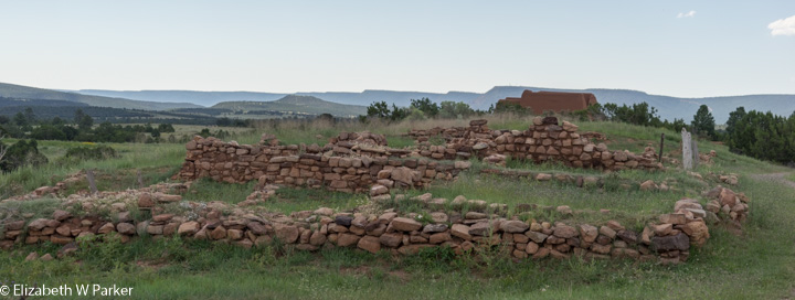
Pecos Nat’l Historic Park – the area to the right of the city wall was the trading field.
In the big picture, we are headed to Taos, but we have all day to get there, so our itinerary for the day is going to take us eastward before turning to the north. First stop: Pecos National Historical Park. This is another archeological site of the ancient Puebloan people. The area is not really like the Bandolier site, this is in a far rougher state. The excavations are just low walls, though they might be of second story rooms.

Pecos NHP – Gerry enters the kiva in the traditional way – through the roof.
There is one well excavated and reconstructed kiva, a round ceremonial room that you enter from the roof via ladder. Inside a kiva there was a central fire pit, with a draft shield. In the wall, an air shaft drew the smoke away and up to the outside. There was always a hole in the ground, too. This would remind the ancient Puebloans that they were created from the ground.
Pecos NHP – Ruins of dwellings
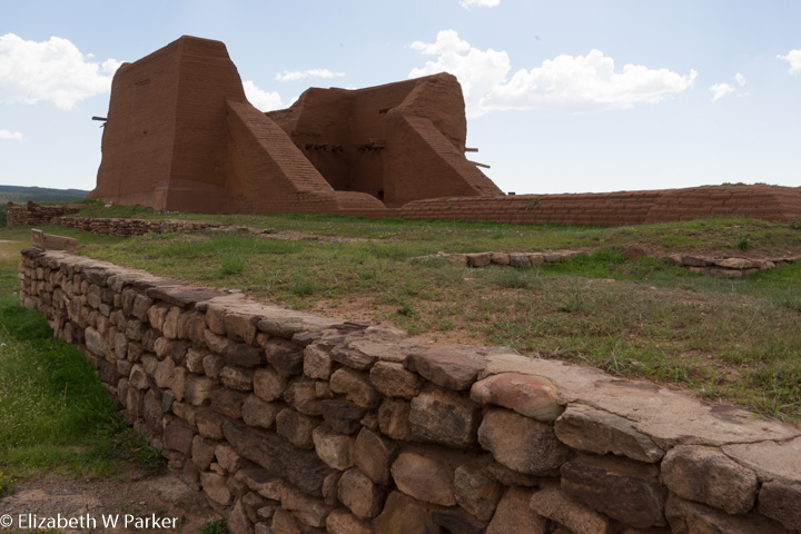
Pecos NHP – Remains of the second mission church
It is a nice, easy walk on a self-guided trail that includes both a pamphlet and markers along the way. What is memorable here is that the settlement included an enormous space for travelers to and through the town to stop and trade or sell wares. This was a town of over 2,000 people, prosperous enough to have an “army” of 500 warriors.
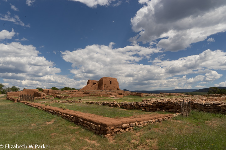
Pecos NHP – the extensive ruins of the mission buildings
The other significant aspect of the site is the remains and excavation of a large mission church and complex. The original building, whose floor print has been excavated to show how large it was, was destroyed in the Pueblo Revolt of 1680. Another, smaller version was erected. Its ruins are those that remain upright now. Excavated to the side of the mission church are the mission rooms.

Pecos NHP – Interior view of the church ruins
An interesting study would be the way in which the native Puebloans adopted Christianity…here you do not see the incorporation of native symbols like you do in Guatemala (syncretism), but in the art (we will see it later in the mission church at Rancho de Taos and others) human figures clearly appear to have indigenous features. And though the Pueblo Revolt was also about the imposition of Christianity, the Spanish missionaries returned to this area 30 years later and successfully converted the people to their religion. Even today, examples of fervent faith are numerous.

Charlie’s Soic and Span – Las Vegas NM
After exploring Pecos, we drove to Las Vegas (New Mexico!) where our first stop was a busy, popular place called Charlie’s Spic and Span. The décor was 50s diner, the menu New Mexican and the clientele very eclectic. We were not out of place in our hiking boots, with attire ranging from Sunday Best to straight off the ranch. We wanted to visit this town because of its 900 buildings on the National Register of Historic Places. We saw fewer than a handful, which was disappointing…but we did not have a good map of the town, nor was the Chamber of Commerce open to get a walking tour map. The town center was unkempt (grass out of control, etc.) but the Plaza Hotel was a gem at one corner of the big central square.
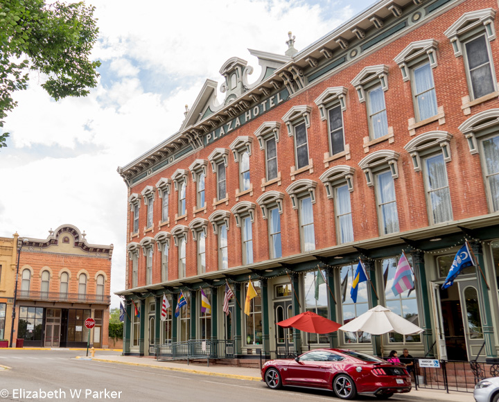
The Plaza Hotel facade – Las Vegas, NM
We had thought to visit the Fort Union Historical Site, but the day had caught up with us so we took Rte. 815 to Taos. This took us through some quaint little resort towns and the Carson State Forest. The forest was beautiful. Around us were some very high mountains, slopes thickly covered with tall pines, cool streams flowed along the side of the road. The temperature dropped from 85 degrees near Las Vegas to 53 degrees in the mountains. We rolled into Taos about 5 and found our hotel for the night, the pretty Dreamcatcher B & B. The owner was very nice and gracious and helped us settle on a place for dinner. It was a short drive from there to the center of Taos, where we made both a pre- and post- dinner walk, eating at Lambert’s on Bent Road. We did some good scouting for our formal sightseeing the following morning.

Taos – central plaza
My only complaint about New Mexico is the prevalence of cars in the historic centers of the towns we visited. Here you have these amazingly restored and maintained historic buildings, so worthy of photographs and yet there are legally cars parked everywhere. Taos, Santa Fe and Las Vegas would all have benefit from a no-parking-on-the-main-square ordinance.
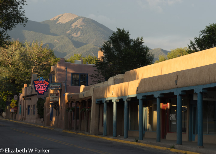
Taos, NM
Monday, August 28, 2017
Monday started with a wonderful two course breakfast at our B&B, which we shared with other guests. Not only was the food good, but the company and conversation was also lots of fun. Four of our fellow guests were from Houston, so we got the latest updates about Hurricane Harvey from their contacts on the ground. We also got good advice about what to do with the short time we had in Taos.
That advice resulted in our driving out of town (it was still too early for the museums and shops in town to be open) to see the Rio Grande River Gorge Bridge. I am so glad we did not skip this!
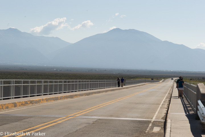
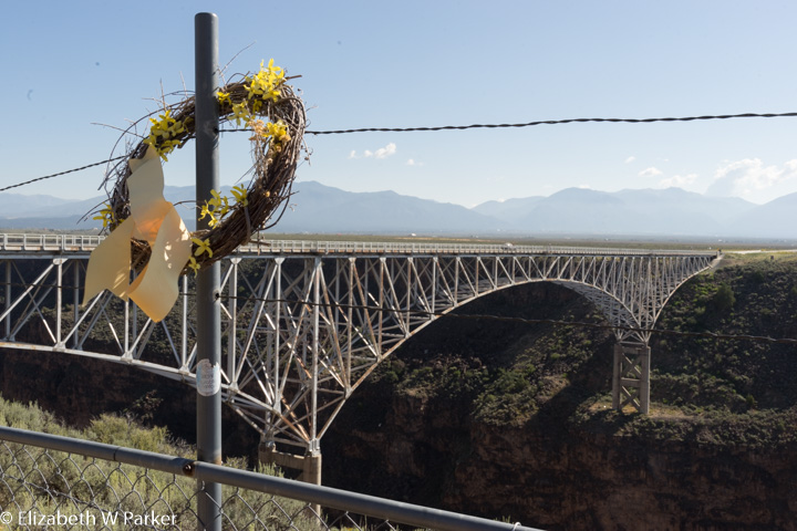
Rio Grande Gorge Bridge
The drive to the bridge was pretty. We were moseying along narrow country roads – the back way – so to speak – and got to see where the residents of this town live and how. Once on the main highway to the bridge we had nothing but desert, red dirt dotted with scrub, stretching for miles on both sides. It was flat and featureless. Almost. The ribbon of road through the desert was intersected ahead by a darker stripe. It wasn’t much. It was just a place where the color of the seemingly endless flat yellow, beige and red ground was dark brown.
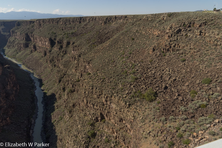
Do you remember a 3-D movie from the 70s that took you up in a balloon? The balloon flew along the course of a river and then over a waterfall. That same sensation is what you get when you drive out onto the Gorge bridge. All of a sudden, the bottom falls out! And, wow, it falls way down! That darker strip of land is the gorge, and you don’t see it as anything other than a darker stripe until you are out on the bridge. The walls of the gorge drop almost straight down. There is nothing on the surface to indicate how wide or how deep the gorge will be. Can you imagine what a rider on horseback would have thought? I just hope he or she wasn’t headed that way at a full on gallop!
Rio Grande Gorge Bridge – way up in the right corner find the picnic shelter and flagpole to give you a sense of scale.
The gorge is a huge slash in the earth. It runs under the bridge for miles and miles in both directions and there are few other places to cross. Without a bridge, it is probably impossible to cross, as the walls are incredibly steep. When you look at a map of the Santa Fe Trail and see how it turns southward before heading west to Santa Fe, this is probably the reason. Pioneers encountering the gorge would have had to travel long distances to find a place where they could cross.

Rio Grande Gorge Bridge
Sadly, the gorge is a site for suicides, and the bridge makes death more certain that throwing yourself off the side. There are hotlines posted on the bridge, but we were told by the locals that on average there are 2 successful suicides per year. Sun-bleached wreaths hang on the fence.
Logistically, there is a place to park off the road on the western side of
Rio Grande Gorge Bridge
the bridge. It is easy to walk out onto the bridge to take pictures and look down, and you should do that. Take a moment, too, to think of the people who decided that they could just not go on from here.
Back in Taos, the town was awake and we parked and walked to the Kit Carson Museum. Kit Carson was quite a figure here in Taos, and he makes an appearance in Willa Cather’s book, too. The museum is in a house that he and his family occupied in Taos. You’ll see a History Channel video about his early life, and you’ll see photos and memorabilia about him, in a setting that recreates the way the family lived. The courtyard is very photogenic!
Taos – Courtyard entrance to the Kit Carson Museum
After the museum, I visited a local artists’ collective gallery to buy a few things. One of the prints I bought will forever remind me of the landscape near the gorge bridge.
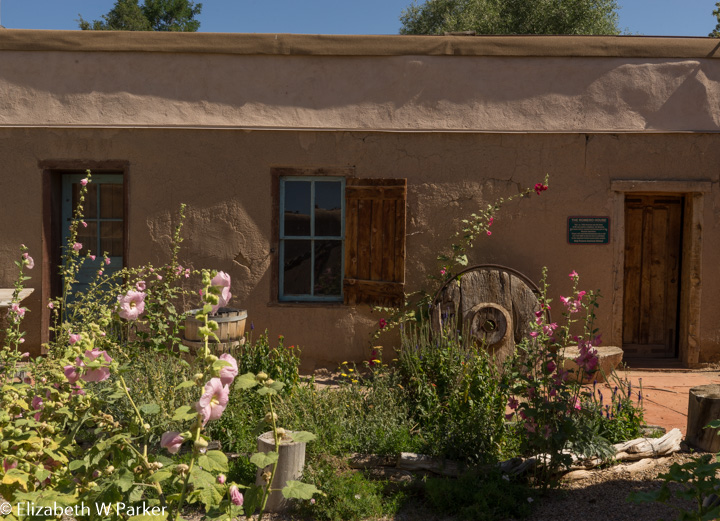
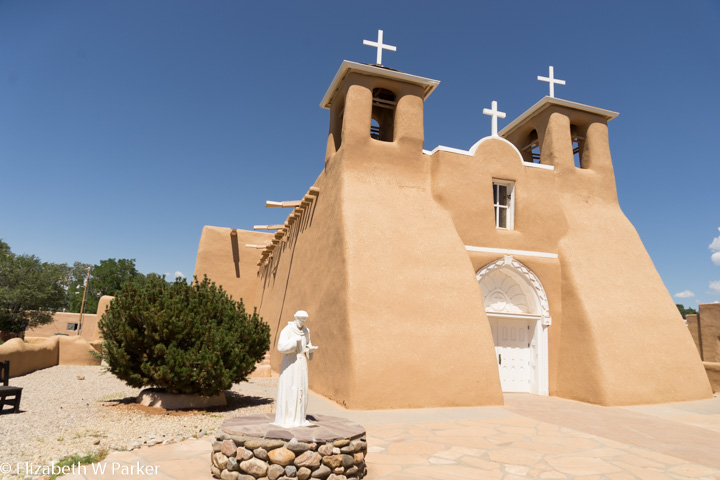
To return to Santa Fe, we decided to drive the High Road to Taos backwards, as recommended by our guidebook (Fodor’s) and our B&B hosts. Barely out of town, we stopped in Rancho de Taos to see the St. Francis of Assisi Mission Church.
Rancho de Taos – San Francisco de Asis Mission Church
What a treat! The exterior is so well maintained by the current congregation of 200 that you get a really good idea of what it would have looked like 200 years ago when it was new. We spoke to a resident and parishioner and he said that every spring they add a coat of adobe (lots of straw mixed in) to cover and protect the original bricks. There were no pictures allowed inside, but it was beautiful! There are no extraneous or modern ornaments – just the original structure, beautifully maintained, and wonderful retablos of painted wood. The effect is so pure and calming. (Sunset magazine described it as soul-stirring!) See it to believe it for yourself.
Back on the High Road we drove to Chimayo to see the Sanctuary – the Lourdes of the Southwest. But first … you guessed it … lunch. Just as we entered Chimayo we happened upon or destination (it did not come up on Google Maps – no signal) “Rancho de Chimayo” recommended for its carne adovada. [Just a short aside here…Sometimes Chimayo is written with an accent on the o – Chimayó. However, no one pronounces it that way, so I am going to write it without the accent.]
Sanctuary of Chimayo
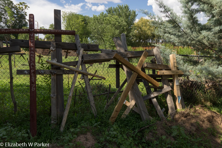
After lunch we found the Sanctuary and explored. From the moment I left the car, I saw crosses and rosaries everywhere. It appeared that places were created precisely to hold all these devotions left behind, as they draped statues, adorned trees, were tied to fences … There were also lots of photos. You could leave one of your own. Instructions for doing that were placed together on signs asking you to pray for the loved ones whose pictures covered many square feet of space in all the buildings. The Lourdes of the Southwest wouldn’t be complete with out crutches and other evidence of infirmity cured, and there is that, too.
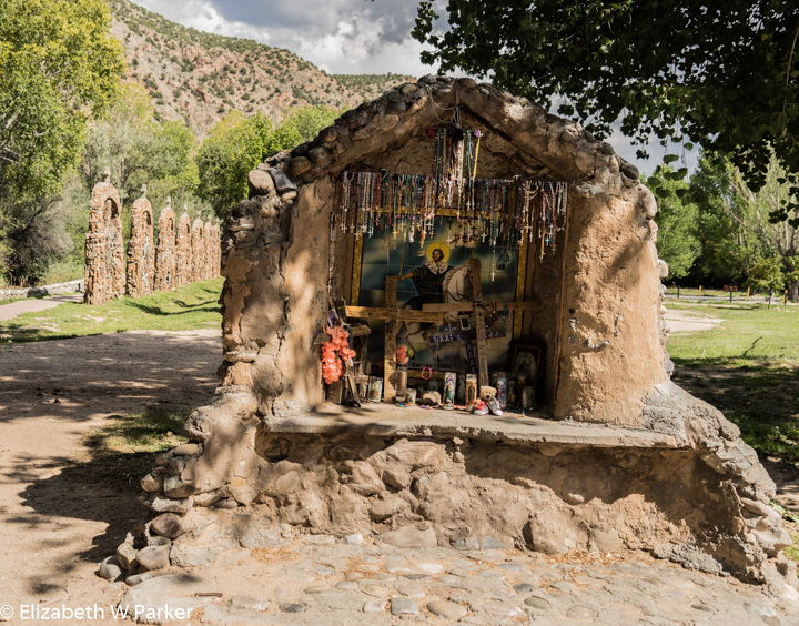
Sanctuary of Chimayo grounds – many places to leave a devotion
There are two sacred structures here. The main sanctuary church and the Niño Chapel. In the main sanctuary church you can get a bit of holy dirt from a hole in the ground of a side chapel. Somewhere I read that there was a similar hole of holy dirt in the Niño chapel but I could not find it. In the Niño chapel is a wooden statue of the Niño de Atocha. Brought to the sanctuary, en route it lost a shoe. The tradition is to leave shoes for the Niño. His devotion room is filled with tiny pairs of shoes, as well as children’s clothes, photos, crosses, rosaries and toys. The building and its decoration appear modern.

Nino Chapel at Chimayo
Again, no photos inside any of the buildings, but outside you will find souvenir shops, places to eat and places to buy a devotion if you didn’t bring one with you.
Once finished with our visit to the Sanctuary, we finished up the High Road and got on the expressway to Santa Fe. The entire drive, without stopping might take an hour and a half. With the stops we made it was a 6-hour trip, including lunch.
Eventually we arrive back in Santa Fe, to stay at La Fonda on the Plaza Hotel, right by the cathedral and the Plaza. We had dinner in Plazuleta restaurant, having made reservations several days ahead. After dinner, we took a short walk not wishing to go to bed on a full-stomach.

Main church at Chimayo
Tuesday, August 29th, 2017
Waking up in Santa Fe was a pleasure. It was so nice to just stroll through the early morning along the Plaza of Santa Fe to have breakfast at Café Pasqual’s, reputed to be the best breakfast in town by some knowledgeable source (take your pick!). Finishing up about 9:30 we walked to the Georgia O’Keeffe museum, just a few blocks away.
The museum is an interesting mix of art and biography. There is a story about how Georgia O’Keeffe did not want either of her homes (Santa Fe and Ghost Ranch) to become museums. The issue of displaying her work to the public was easily solved as most art museums are not located in previously private homes. But how to talk about the woman is not as easily solved outside of showing her personal spaces. Here, the personal side is shown through photographs taken of her by contemporaries, notably her husband, Alfred Stieglitz but also others, and the text accompanying the photos also reveals the indomitable personality of this phenom of the 20th century.
I don’t call her a phenom gratuitously. As an undergrad art history major it was not lost on me that much (if not statistically all) of art history education is dominated by male artists. What Georgia O’Keeffe accomplished only points to how important were her contributions to the development of American Art, given that she had to overcome the inherent bias for male protagonists. I am sure her relationship with Stieglitz helped propel her into the spotlight and made it hard to ignore her (he was a gallerist as well as a photographer). Looking back, it all seems so clear and easy now, but even in the 1970s, when I was studying art, she was clearly a pioneer for women artists.
To see Georgia O’Keeffe’s work in New Mexico, in the context of where she lived and created much of her most famous work, is really a treat. Part of our photography workshop included visiting Ghost Ranch, which unfortunately we did not get to do on this trip. However, her vision, her colors, her abstraction of her personal landscape around Ghost Ranch is visible in other landscapes in this part of the state.
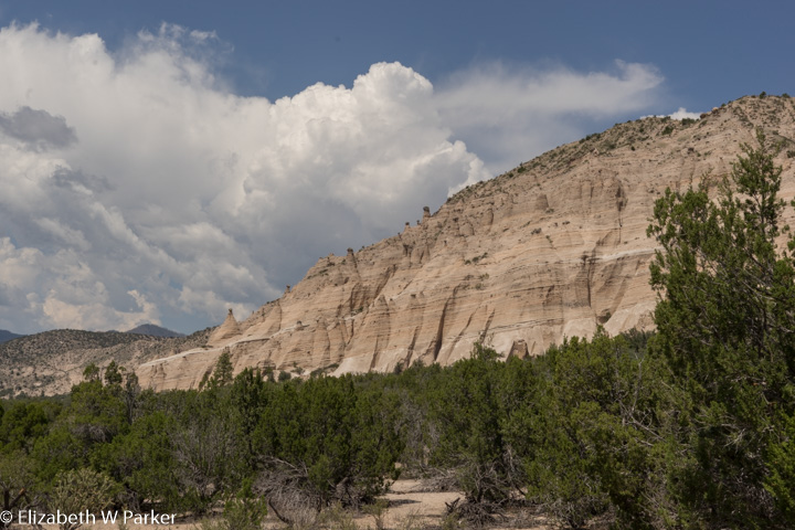
Kasha Katuwe Tent Rocks National Monument
It is with these images in my head that we drove to the Kasha Katuwe Tent Rocks National Monument on our way to Albuquerque. “Tent Rocks” was the other (of the 4) destinations that we were not scheduled to see as part of our photography reunion. Happily, we had the experience of other reunion participants to guide us as to how we approached the hike.

Kasha Katuwe Tent Rocks National Monument
Leaving the parking area provisioned with water, sun-screened-up, hatted and booted, we took the 1.5 mile (each way) “Canyon Trail.” It was flesh-roasting hot! Not only was the sun overhead – but the rocks are white and the glare and reflected heat was prodigious! People coming back down the train were red-faced and exhausted.
We moved from shady spot to shady spot. Most of the pictures I had seen of what awaited us on this hike were the famous tent-shaped white rocks, but there are trees, too. I mention them here for their shade, but they were also pretty fantastic: Their reddish-brown bark and dark green needles are wonderfully contrasted by the white rock, and their roots are twisted and polished like something from a Harry Potter forest.

Kasha Katuwe Tent Rocks National Monument

Kasha Katuwe Tent Rocks National Monument
Certainly the rocks are the star attraction. Our path wound through them, sometimes as wide a city sidewalk, other times as narrow as your foot. Watching where you put your feet could distract you from looking up and around you, but you have to stop and to do that because here is a landscape so unique and wonderful.
The tent shaped rocks are the result of weathering. Made from tuff (petrified volcanic ash), other sediments and pyroclastic materials, the softer rocks weathered fasted than the harder. The rocks of the most recent layers are hard, so some of the “tents” have little cap-stones that protect them. The softer rock has mostly weathered (wind and water) into cones (the tents). They are anywhere from a couple of stories to many stories high. Some of the capped ones look like humanoid characters a child might draw, complete with facial features!

Kasha Katuwe Tent Rocks National Monument – Slot canyon
In addition to the “tents” there are narrow breaks in the walls of rock and these are brushed and smoothed by water into sensuous curves of white and pink and beige.
As we hiked the ground began to rise and we had to climb up over fallen rocks and trees. Then it got steep. The altitude here is high to begin with, now start climbing a pretty steep rise and you can imagine how quickly and often we were out of breath. Fortunately, as we went up, a storm was building just off to the north, blocking the sun and producing a cool breeze that took away the additional challenge of doing this in the incredible heat of down below.

Kasha Katuwe Tent Rocks National Monument – Slot canyon
The hike up, and the rise is about 630 feet, is not so arduous that you cannot do it (though that thought may certainly cross your mind!) Eventually, there will be wooden steps to help you, and previous visitors have worn down alternate routes around some of the obstacles. Getting to the top is definitely worth the effort!
From the top, there are many views to choose from – looking southward toward the high desert landscape that dominates much of the area, looking eastward to the mountains and mesas and plateaus, resplendent in color, looking to the north was the storm (thunder audible), but looking down was the best! To see the tent rocks from above was unforgettable. Their grandeur – size and bulk – is quite something when seen from above, and it completely changed my perception of them on the hike back down (this hike is not a loop – you go up and down by the same route).

Kasha Katuwe Tent Rocks National Monument
Whether heat or exertion was the culprit, we were drained afterwards. It was all I could do to keep my eyes open during the 55-minute drive to our hotel near the Albuquerque airport.
We spent our final evening in the Albuquerque Sheraton, just 5 minutes from the airport. Chosen because we could sleep in before our 8 am flight, it fulfilled that task ably. And so this adventure ended.
I really loved New Mexico. The landscape and the rocks are not as dramatic and beautiful as they are in Utah, but the fact that they are hidden, and you have to go find them, makes a trip here very appealing. Best of all, the people in New Mexico were open and friendly. I must have remarked about it every day. It really made a trip here a pleasure…every store or gallery we entered, every restaurant, every tourist sight, even right on the street…nice, friendly people all.
I will go back to New Mexico. Besides Ghost Ranch, there are many other National Park properties to see, and state parks, too. I am dreaming of doing it all in a camper …

Sunset from Santa Fe

You must be logged in to post a comment.