
The entrance to the Hyatt Carmel Highlands
(July 25) As I mentioned earlier, my plan for these next days was to explore the Pacific coast from a base in Carmel. Only once I was here did I realize that the distances involved would mean a lot of hours in the car and not much time for actually seeing things…That is what happened to us on the drive from Santa Barbara – we didn’t get to see everything I had planned and then the long drive to Carmel put us off driving for a few days.
But, being flexible, when absolutely necessary, I revised my plans. Rather than go south back to the Hearst Castle, we could explore the Monterey peninsula first and save San Simeon for the day after..

Not much to see on Fisherman’s Wharf, early in the day when it is cloudy and cold…
But, we woke up to fog. We decided to try to see the Monterey aquarium while the sky was cloudy and then when it cleared, do some outdoor things. We never did make it to the aquarium. We got sidetracked when we parked right near Fisherman’s Wharf. How could we not walk the wharf when it is right here in front of us? Then we got sidetracked again when we walked the Old Town to find the Royal Presidio Chapel before returning to our car.
Before we could do anything else, we had to buy ourselves warm jackets. For us, the day is freezing! Boy we have seen some righteous temperature swings on this trip! The Wharf does not appear to be a place to go in the early morning…there weren’t too many people around and next to nothing was open until well after 10.
This entire area around the Wharf, the Old City and the Presidio is part of the Monterey State Historic Park. It’s unusual to think of an urban area as a state park, but I know many others exist…we just don’t focus on the name. We stopped to look through the museum, located in the Custom House and so got a feel for the area. Fun for me was realizing that the Stevenson House got its name from Robert Louis Stevenson, the author. The museum is well-done, divided for historic people and for historic structures. It was also the first glimpse we got of the native people of this area.
Walking through the town, we picked out historic buildings like the Monterey Hotel (we had one by that name in Janesville, WI too!) and the State Theater. The Royal Presidio Chapel proved a photogenic stopping place. From there we turned around to find our car.
After all that, we did set out again for the aquarium, but finding a place to park was impossible. The weather had not improved. Apparently every other tourist in the area decided it would be a good idea to go to the aquarium, too, and we just could not deal with the crowds.

Harbor view near Pacific Grove
Driving around the coast in Pacific Grove, we stumbled upon the Point Pinos Lighthouse. A visit was very informative. The lighthouse is only open in the afternoons, every day except Tuesday and Wednesday. It is staffed by volunteers, and the docent in the basement explained the functioning of the light itself. This is the oldest functioning lighthouse on the West Coast and it has had several female light keepers in its history. Definitely worth a stop, and if you have a sunny day, there might also be a view!

Point Pinos Lighthouse
By now, we’re hungry: The coffee we had on the wharf has long worn off! We set out to find lunch. But, it’s Monday. Many good places are closed. We ended up in an easily forgettable diner called the International Cafe (with one dish from each of about 20-25 countries.)

I couldn’t resist photographing this handsome bird!
Then, we took the 17-Mile Drive (the name is trademarked…) to see amazing landscapes of the ocean. The drive goes through and around the coast within the Del Monte Forest. It’s private property, so you must pay a fee to enter.
There were lots of photo opportunities along the route. The weather had not cleared as we had hoped. It was probably due to the fire. Did I tell mention the fire? (I know I have alluded to it a couple of times: Rhetorical question!) This is the fire that is reported on the news as the Soberanes Fire…burning in the mountains to the east along the No. 1 highway – exactly the area we were planning to explore. It is close to our hotel, which is close to Monterey, so perhaps all the dark overcast skies and somewhat foggy atmosphere is actually cause by smoke?
“Close to our hotel”…Lets revisit that. When I checked in, the desk clerk handed me a piece of paper. (Note: He didn’t tell me, he gave me a paper.) I read it without really comprehending, never before having had a piece of paper given to me at check-in, with a huge font, telling me that the Fire Department has warned the hotel that it might have to be evacuated. I am to stay alert and the front desk will tell me what I need to do in the case of an evacuation and where the shelter is. Really? The clerk assured me, as did the waiters in the restaurant, that we would probably not have any problems during our stay. “This is just a precaution,” I was told. OK….

Another view along the 17-Mile Drive
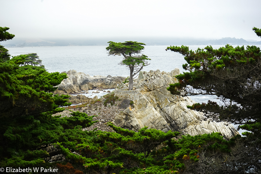
The Lone Cypress
Back to the 17-mile drive: We had the time and decided to follow the tour route provided in the brochure they gave us at the entrance. You have to pay to drive the route, but I didn’t feel like that was any deterrent. The focus of the drive is on the Pebble Beach golf courses, but the tourists pay the fee to drive the route and see the coast, which otherwise would be cut off from view. There route map gives you 21 landmarks along the drive. Some of our favorites (and those of the other tourists, too!) were Spanish Bay, the Restless Sea, Point Joe, Bird Rock, Fanshell Overlook, Cypress Point, Crocker Grove, and of course, the Lone Cypress (whose image is the logo for the Pebble Beach Company). We were not able to locate the Ghost Tree, but then we were dodging a tour bus of Asians.

Any day is brightened by pretty flowers and plants!
Unfortunately, our sky was neither dramatic nor nice, so just try to ignore those big white areas in the pictures. I think you will still see that the coast is, itself, quite dramatic, and you should probably go to see what a much better or much worse day might bring.
We exited the 17-Mile Drive in Carmel-by-the-Sea and drove the sea route there. Really memorable for us were all the little gnome houses. There were many other styles, too, all fascinating to imagine oneself living in.
From Carmel-by-the-Sea (we did not find the quaint little downtown of artisan shops), our route back to the hotel took us right by San Carlos Borromeo de Carmelo, another mission. Founded in 1770, the mission was notable for the Moorish influences in its architecture.

Carmel Mission – San Carlos Borromeo
Leaving the mission, we wanted to stop at Los Pinos State Park but it was closed because of the fire…We also noticed evacuations underway from residential areas on the east side of Highway 1 and north of our hotel. Our anxiety levels rose, as you can imagine.
Back at the hotel, there is a heightened state of alert for the fire but still no call to evacuate. As instructed, we packed and got ready just in case. We did our laundry and had dinner again in the hotel. We just didn’t want to get too far away in case we needed to evacuate. Not the real reason! We had to go back to the Pacific’s Edge Restaurant and have the delicious octopus again!

Interior of the Carmel Mission
During the night we did get a late call to be ready to evacuate…Another never came. However, we decided to check out anyway and miss our final night. It was too bad, because we loved the hotel, but the air was so smoky that we couldn’t enjoy it even if there had not been the added anxiety of the impending evacuation. Once we left, we never did find out if the evacuation ever took place. The hotel was virtually empty when we checked out.
(June 26) The fire also ravaged our touring plans for the Pacific Coast Highway, the Number 1. It was so hazy, smoky and foggy when we woke up on the 26th that we couldn’t see a thing. We drove south along Highway 1 anyway, but with all the state parks and forests closed, we couldn’t get to see the things we wanted to see. Mostly we couldn’t see much beyond the road right in front of us. There was plenty of regular traffic on the road – something I felt funny about because the road was definitely the staging point for all the emergency fire equipment. On the way back we counted – more than 30 large trailer trucks for bringing in bulldozers and heavy equipment and well over 20 fire vehicles. We didn’t count the many trucks that must have transported the fire fighters.
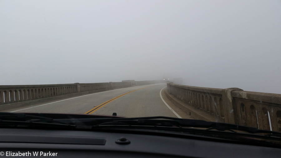
Driving into … who knows what? Fog and smoke from the Soberanes Fire obscured everything.
Along the road near Big Sur, we were away from the coast and south of the fire. Here the air cleared and we could see the beautiful woods and tourist areas that flank the Big Sur River. It was lovely. We did not end up stopping for lunch at Nepenthe. The restaurant is renown for the view – with the fog and the smoke, today there isn’t one.
Back up in the Monterey area again, our car was acting up and the check engine light was on so we went to Hertz at the Monterey Regional Airport to have it checked. They found nothing so we continued. We headed up to Moss Landing to see the “sea lions.”

Foggy harbor in Moss Landing
Our maid at the Hyatt recommended a place for us to have lunch. Doubts aside we decided to go for it and had a delicious lunch in a place called Sea Harvest Fish Market & Restaurant. The place was a little funky, with a large but enclosed “outdoor” area. It wasn’t that warm, so we appreciated the cover. Out the windows we could see a small harbor to our left, with a fair amount of traffic, moving in and out, especially commercial fishing boats. To the front and right was a protected, natural area, the Moss Landing State Beach. This was our destination, we had come to see sea lions.
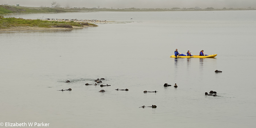
The shapes in the water are the sea otters floating around on their backs.
The waitress explained that the famed sea lion pier had been removed because it was attracting too many animals. Instead, we would have to see the animals in the wild. Kayakers and canoeists paddling colorful craft while we had lunch turned out to be excursions peddling paddling among the animals. It did look like fun! The sea otters were rolling and playing in the water. How great to have a front row seat for that!
After lunch, we drove to the state beach and walked a bit. The park is full of dunes with the ocean crashing on the west, beach side. The east side is where the harbor is and where a lagoon serves as a playground for the sea otters. Pacific harbor seals were sleeping on the wet sand. We did not see any real sea lions.
Our new hotel for the night is in Los Banos, CA. The incentive was that the drive there would take us part of the way to Yosemite, shortening our time in the car the next day. Back we struggled into the triple digit heat! Nothing to tell you about Los Banos. Avoid it if you can. Our hotel was nice enough but the food options were dismal.
The drive to Los Banos from the coast was interesting though…lots of very large agriculture. We saw artichokes and other ground crops, as well as hundreds of trees – almonds we were guessing. The standout feature of all this? Irrigation. There was even a sign that said “Is it a waste of water if you grow food?”
Unfortunately, my answer would have been yes. Especially when you find out that the water used to grow all these crops in areas where they would not grow naturally is coming from the snow melt in Yosemite…snow melting into a Yosemite lake that was dammed to create a reservoir – commercialized and not available to park visitors for recreation!
More about that coming up! The next and last section of my trip was in Yosemite National Park.

A last look: Ocean view from 17-Mile Drive

You must be logged in to post a comment.