
Sunset
Joshua Tree National Park (July 2016)
(July 20) We arrived at our hotel in Yucca Valley at about 6:30 pm. We rested a bit and then gathered our gear and went to find some dinner. Our original destination was closed but we found a Thai place quite near the turn-off to the park entrance in the town of Joshua Tree. (The other towns around here are Yucca Valley and Twentynine Palms…) I find it fascinating that there aren’t better places to eat near the national parks…Yes, we have found decent places – but we have had to return again and again to the same place, because the options are so limited. I am curious about that!
Summer is the low season for this park. It may seem odd at first reading, since the national parks are the stuff of summer road trips and family vacations, but Joshua Tree is desert, and in the summer it is VERY hot. Over the course of our three days here the temperatures during the day were between 90 and 110, and at night ranged from 75-85. We were not overly concerned since we came to do night photography, and planned all along to be out when it is cooler. Of course, I had not factored the rattlesnakes into that equation…They are a lot harder to see in the dark, and they also like to be out when it is cooler.
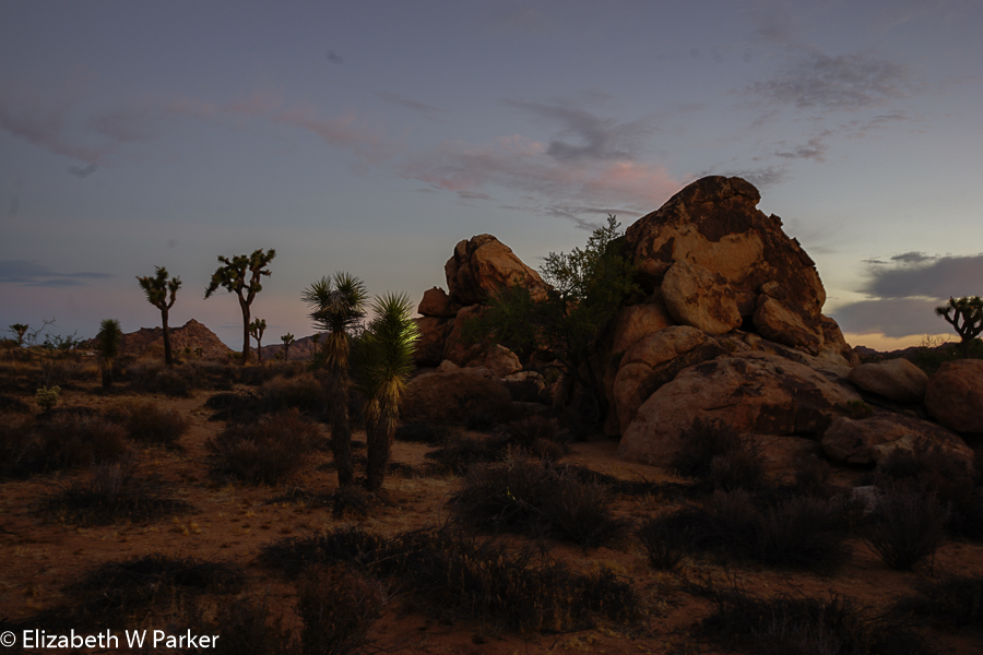
That first night we entered the park about 9 pm. There was a brilliant yellow glow behind the mountains to our left – a full moon rising. Again, Joshua Tree is a favorite with night photographers because its skies are not polluted by light from cities and so it is a perfect place for capturing the Milky Way. We were aware we would have a full moon and were looking forward to photographing moonlight and shadows, light painting with a flashlight, as well as capturing the silhouettes of the Joshua trees against the brighter sky.
We were not disappointed. You can judge the results yourself.
Alone, in the middle of a desert, at night, surrounded by brush, rocks and the yucca trees; animals unseen around me doing their nightly routine; the moon casting a faint gleam over the landscape, a now just-warm breeze ruffling my hair: It was magical. Tiredness and cares of the day are gone, and energy seems to come from without and fill me with a sense of well-being and wonder. I would spread my arms and tilt my face upward to catch even more of that desert night.
A short sleep ahead of us, we returned to the hotel about 11:30 pm and woke up to return to the park at 4:30 am.
Sunrise
Sunrise
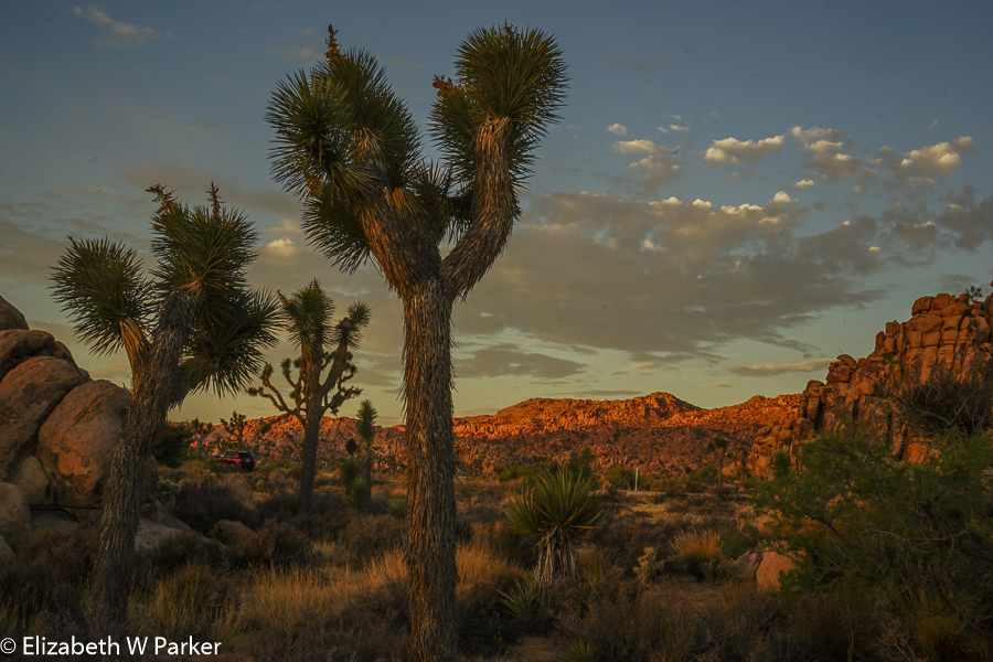
Shooting at dawn is harder. By the second the amount of light is increasing and we are changing our camera settings after every shot. First light was around 4:50 am, sunrise about 5:30 am. We didn’t get sunlight on the rocks until almost 6 as it had to rise sufficiently high to clear the mountains to the east.
For the first time, I can see the landscape around me. The Joshua trees dot my view. The area between the “piles” of boulders and the mountains is flat and sandy. There are other plants, typical desert plants, scrubby, pointy, rather unfriendly looking. In the light of the dawn, everything is weird and beautiful.
Someplace I read that the Joshua trees look like creatures from a Dr. Seuss book. Boy, that’s a good description! They are very weird – in the daylight and by moonlight. I read up a bit about them; they are interesting plants. First, in order to branch, they need to flower, in order to flower they need just the right amount of rain, at the right time and they need a short, sharp freeze to kill the tip. Otherwise they just continue to grow straight up. Seedlings grow quickly, but once established, the plant grows slowly. It is a useful plant, but only the flower buds and seeds are edible. Leaves are good for basket-making, now there’s a lost art! In the time we were in Joshua tree I never tired of looking at the trees. Each one seemed unique, despite its being made up of the same parts.

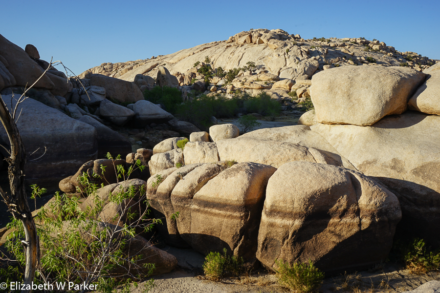
A pile of boulders… Notice the size of the Joshua trees in front of them…
I loved the rocks. The boulders are by turns large and rounded, large and pointed, large, large, large. These are granite extrusions, about 100 million years old, formed in pre-history, buried for eons and slowly emerging as the surrounding rock and soil is weathered and eroded away. Their variety is amazing. Their textures, too. They look like big rounded pillows, smushed into funny shapes and then piled willy-nilly onto the sandy sofa of the desert floor.
Here the boulders and rock piles are most times discreet. They do not always have a lot of company. They just seem to have burst through the earth all alone. They certainly make you wish you could blow away all the sand and dust to reveal a chain of boulder mountains below the surface. What we can see was laid bare by flash floods.
I was thinking this morning about the prosaic names of these boulder communities, given them by local tradition or the National Park Service. They have names like Skull Rock, Garden of Horrors, Hemingway Buttress, Lone Horse Wall. What’s missing? AHA! No corporate sponsors! Yahoo! No “United Airlines Skull Rock”, no “Trump Garden of Horrors” (though that might be appropriate…). It is strange that it took me several days of mulling it to come to that “aha” realization.
Once the sun was up, we still had a hour or so of good light for pictures and we went to see the Keys View lookout. Located in the southern part of the park about 5K feet up we had an amazing view. I am forever struck by the vastness of the landscapes here in the West and this view was another of those times. We could see the Salton Sea from our vantage point, and just barely make out the mountains in Mexico.

Keys View. On the far left, just above the mountain, look for a light blue strip. That is the Salton Sea. You can pretend you see the mountains in Mexico. I did!
Joshua Tree National Park is made up of two distinct desert ecosystems. The one we are in, the high desert, is the one that supports the Joshua trees (Yucca brevifoglia). This is the Mojave Desert. The other, which we can see from here, is the low desert, specifically the Colorado Desert a subsystem within the Sonoran Desert. From our vantage point it looks empty and barren. (We will drive through it tomorrow and discover than it is anything but!)
Haze is an issue for this viewpoint. Far to my right, there is a deep break in the mountains, a huge valley that gives access to the ocean side of the mountains. There are hundreds of windmills there. The rising hot air in the desert on this side, pulls in the cooler ocean air on the other. It is a boon for wind power, but not so great for pollution. Once the polluted air is in the desert it appears as haze and makes it difficult to see the distant landmarks, like the Salton Sea and the mountains of Mexico. This morning there was just a bit…but photographers’ plans for a sunset or sunrise shot are often foiled by it. Calm days are worse than windy ones.
The light in the desert is also different. I could not put my finger on exactly what it is about it, but it is flatter, harder, harsher and uniquely appealing. For me, it is as hard to capture on digital film as it is in words!
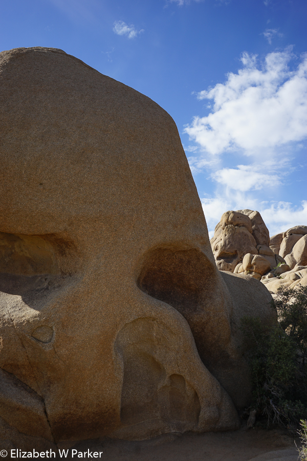
Skull Rock
After the Keys View, we went in search of Skull Rock, which we found by taking a walk from the campground on a nature trail. It was so hot already (just 9:00 am and already mid 90’s) that I had many, many second thoughts about the wisdom if not the desirability of walking to find it. (Especially since we discovered that we could have driven right up to it!) Like the arch we would find later in the day, it is not easy to photograph, making you wonder who took the pictures for the brochures and how did they take them?
We spent the hottest part of the day in the hotel, sleeping, catching up for a short night before. About 5:00 we emerged to near 100 degree temps and had “lunch.” From the air conditioned Subway to the air conditioned car, the moments of heat in between reveal a very dry, oven-like heat…we were thankful for a day spent in the shade of our air-conditioned hotel room!
Barker’s Dam
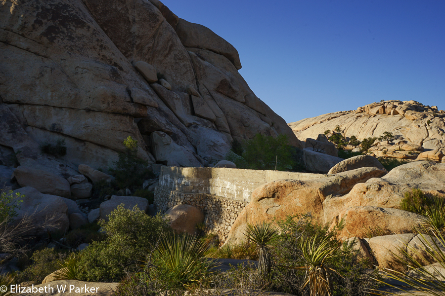
From lunch, we went off to locate Barker’s Dam. Access to many of the human artifacts that remain in the park is carefully controlled. Visits to old gold mines and ranches are via a ranger guided talk, some with an additional fee. None were options for us in late July on a weekday, and probably more importantly, not at the times we were planning to visit the park (early mornings and evenings). Barker’s Dam was an option, though, and so we parked and took the short nature trail through the improbably huge boulders and scrubby shade trees to find this human structure, a remnant of a Barker’s ranch probably, where the family built a dam among the rocks to hold precious water for cattle. You can still see the dam, as well as the lines on the rocks that must indicate how high the water could get. That line was impressive as the area dammed was not small.
The water marks on the rocks at Barker’s Dam
One of my favorite things about Joshua Tree National Park is the multitude of explanatory “exhibits” (that’s the word the Park uses). They provide lots of information, most of it new to me so I am an avid consumer of their content. Here at the dam, they explain how the seepage and leaking of the water from around the dam allow certain types of desert plants to flourish. Obviously these are plants that need more water, but that also grow larger, have marginally larger leaves and actually provide forage and shade! A sort of man-made oasis?

Fool’s Gold!
Another interesting feature of this walk was finding native petroglyphs among the rocks. In this area there are almost caves, likely spots for native peoples to stop when traveling through. The “exhibit” about the petroglyphs states that those we can clearly see have been traced over with paint by vandals. Vandalism is a problem for all our national parks, and here the exhibits ask you to report any vandalism of the rocks or trees to the rangers, hopefully with license plate numbers, but without challenging the defacers directly. Rangers waste time they could spend on improving and maintaining the hiking trails trying to erase traces of vandalism…paint on delicate petroglyphs cannot be removed, just as gouging one’s initials in a tree trunk does not permit removing them and causing further damage to the tree. Unfortunately, there are those who see the initials of others and then think it is OK to add their own.
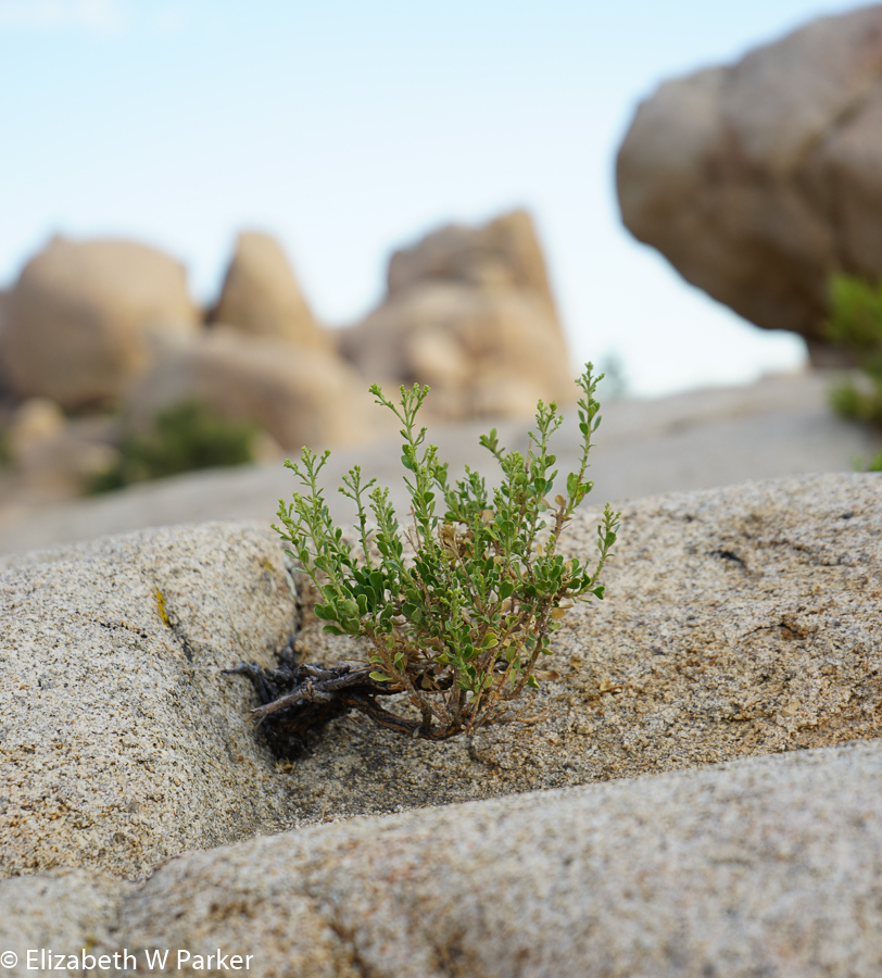
A fighter! Notice that the rocks are not at all smooth, though they look like it from afar.
On the subject of human visitors to the park…where are the Americans? My experience, albeit not conclusive, is that the majority of the people I meet in our national parks are foreign tourists. If you want to meet people from all over the world, just go to a national park! I am glad that they are here, but I don’t want to think that their appreciation for our natural wonders is greater than that of our own citizens.
After Barker’s Dam, we set out on an unpaved road, a short cut, to find the White Tank Campground to photograph “the arch.” En route we passed another campground that is closed for the summer. How odd it is to think that we are here off-season – in July! All the campgrounds we have seen so far are nestled within the mounds of huge boulders. It is a unique arrangement for me, providing both privacy and protection from sun and wind. None has been empty, and none have been crowded: Campers in tents and RVs are scattered among the sites.
The arch is an interesting piece of rock resembling an elephant’s head and trunk. It has nothing on the spectacular arches of Arches National Park, and was hard to photograph. We were not there at an interesting time of day to shoot it either…it is nestled in larger rocks and the light of the sunset does not reach it. I speculated as to whether this might be a morning shot, but I am guessing, not even that. Maybe that is why I haven’t seen a picture of it published.
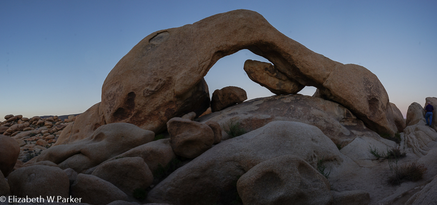
The arch
Leaving the park about 8:30 pm we exited near the town of Twenty-nine Palms (as we have been doing since it puts us onto a straight highway that feels like a shorter way home). We used our GPS to discover the 29 Palms Inn where we had an excellent dinner. The inn is both a lodging and eating establishment, filled with foreign tourists and the colorful individuals who pass for locals in these parts. We had very good food, and enjoyed a welcoming, cheerful atmosphere, too!
Arising not-so-early on Friday (July 22), we planned a long drive through the park, from the entrance near Joshua Tree (town) and out the exit near Cottonwood Springs. It turned out to be exceptionally long, but worth the extra time and miles. By doing so we got to see the Colorado Desert portion of the park. Remember I said it looked empty? It wasn’t! What a wonderful land of strange and beautiful desert plants, all new to me!
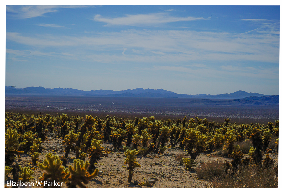
A sea of cholla cacti
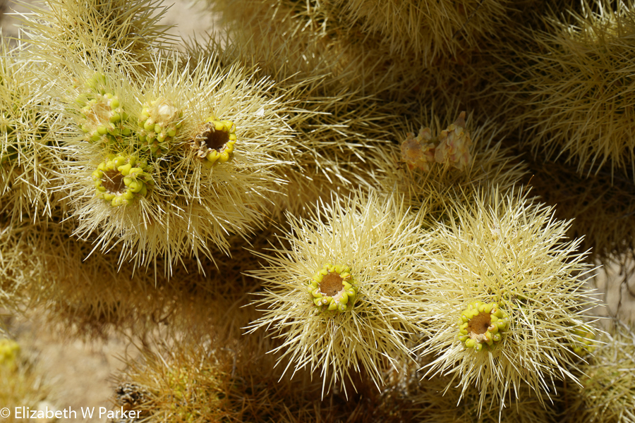
The cholla up close
First we stopped to see the Cholla Cactus Garden. These plants actually cover the desert floor so thickly that from far away you cannot distinguish them. Up closer they appear as millions of dots, and when you’re among them, of course you are quite aware of them as discreet and extremely prickly looking individuals. Lots of exhibits along the road helped us to discover other plants too – the very odd ocotillo for one. The ocotillo is not a cactus but a shrub, with tall straight branches that reach toward the sky sometimes with a little wisp of dead flower at the tip. The stems are thin and have the scars of leaves dropped earlier in the season. We actually (and much deeper in the valley) saw one with leaves: They are small and densely whorl around the stem up to the top. No wonder it is often mistaken for a cactus!

The ocotillo

The tips of the ocotillo branches
This low desert ecosystem is also prone to flash floods. Many of the plants grow in the alluvium which, fortunately for them, is a huge plane in this part of the desert. It is hard to get a feel for it while you are in it, so aerial maps of the area help to show you how vast the alluvial plane is. Ironically we also saw it from the plane on the day we arrived. Looking down from the air, we did not know what we were seeing. Was it glacier, or snow or water? But the color was all wrong. Now we know that what we were seeing was the gray dust, sand and rock of the mountains being washed into the valley.

This is a pic taken from the airplane – it shows what we later discovered was the flood wash of stone rock and dirt out of the mountains into the Sonoran Desert.
With that lingering, lost feeling of saying goodbye to a dear friend we left Joshua Tree and headed back to the greater LA area for a wedding. The parents of the bride in this wedding are friends we have been traveling with for years – originally from the all-important Oaxaca photography workshop and then through stints in San Miguel de Allende, Portugal, Puerto Rico and Germany last year on our Viking cruise. We were so please to be included in the festivities.
Here is a link to the National Park Service pages about Joshua Tree.
And, if you would like to continue following this trip, just click here to read about our day of visiting the missions in central California.

You must be logged in to post a comment.