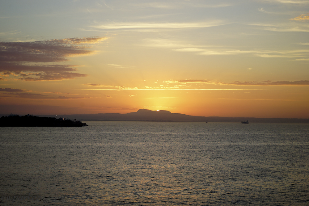
Dawn from the hotel balcony. Dovetails nicely with the sunsets of last night.
Saturday, early morning, I went out onto the balcony to catch up my blog writing and photograph the sunrise. I haven’t figured out exactly in what cove of what bay our hotel is located, but as it is the sun rises at about 11 o’clock. The lovely pinkish sky should have been my clue that the nice weather I hoped for and needed to make a successful day of beach exploring was not to be.

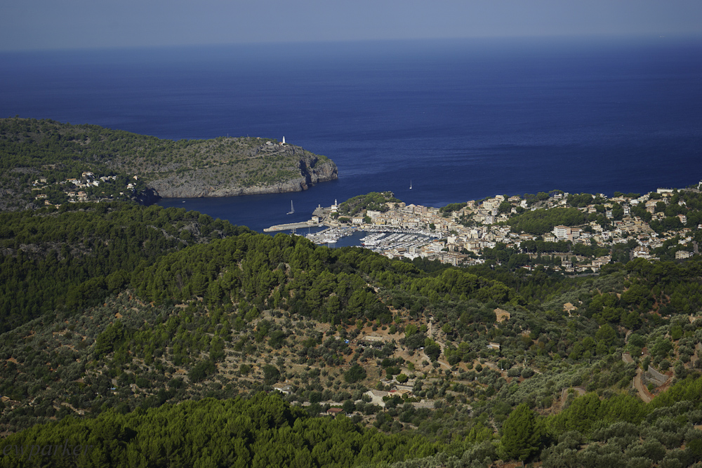
The tunnel to Soller.
But, early morning sunshine well in command, I dressed for the beach and set off early for Cala Tuent, the church (hermitage according to guidebook and map) of San Lorenzo, Sa Calobra and the Torrent des Pareis (torrent of the twins). These four sights are lumped together on the map. It felt like hitting four birds with the proverbial single stone!
[Cue The Beatles: “The long and winding road”] Long and winding doesn’t tell half the story! We managed to cut out a good portion of curvaceous mountain road by taking the tunnel to Sóller (pronounced like [Tom] Sawyer). Two miles long, and dark, it was worth every minute of going straight! Most of our day was spent in first gear, believe it or not. Between tour buses, bicycles, motorcycles and the other cars, on narrow, usually shoulder-less roads, in hairpin turns, and along steep drop-aways – any faster was not an option!

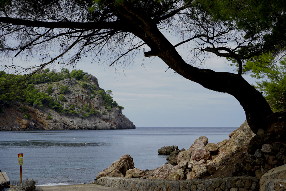
The road to Cala Tuent and Sa Calobra. Curves anyone?
But it was thrilling! That’s not an exaggeration. I am talking heart-in-your-mouth-butterflies-in-your-stomach thrilling. Hold your breath? The drive gave “breath-taking” a literal meaning! And, it was spectacular!

We stopped here for breakfast.
Wow! I am waxing poetic here without even telling you where we were! From Palma, we took the road to Sóller (that’s when we took the tunnel to cut off the first part of the curves). Sóller is a lovely town in the Serra Tramuntana – the mountain range that spans the western coast of the island. From Sóller, we drove northward, probably about halfway between Sóller and Lluc, when we turned off the main road and headed toward the coast on a secondary road. From Sóller onward we are driving in the mountains. These mountains are sandstone. The rock has been uplifted, and now millennia of erosion since infancy have left a range that is studded with jagged peaks and scoured by deep gorges. The rock itself appears as so many sentinels, upright towers of stone that guard the coast and watch the sunset every day. The roads wind up the sides of the peaks and down again into the gorges. A mile as the crow flies could be 3-4 miles of road.
The view from the place we stopped for breakfast.
So, yes, it is spectacular! And when you finally descend to the level of the sea, there are the calas or coves for which Mallorca is rightly famous. Beautiful beaches hide in these coves, with clear water that might glisten as emerald, aquamarine, topaz or even navy in the sunlight. More inviting swimming you will never find. That’s what we planned for the day.

The Church of San Lorenzo
We did stop at the church of San Lorenzo – though I could find nothing of the “hermitage” of its name. It was a convenient place to rest the clutch foot and let those braver (translate “wanting to go faster”) or less cautious pass ahead of us on the road.

That’s Cala Tuent way down there.
Finally we arrived at Cala Tuent, a rather large cove. The views were pretty, a particular pine reaching out across the walkway made a nice a picture. The beach was stony, lots of very round stones of all sizes. True, there weren’t many people, as the guidebook promised. But I think there must be individual tastes in calas, as there are in foods. What is delicious to one person, is not the same as it might be to the next. Though this cala is pretty, my taste in calas runs to the much smaller ones, much more dramatically located at the base of steep cliffs. Cala Tuent was not that. It was not nearly as remote as I had pictured either. There was a bed and breakfast along the road, and a parking area (empty tour bus, too, though no sign of tourists). There were three dwellings, too, and a cultivated olive grove along the back of the beach.

Cala Tuent – bigger than my ideal cove.
Cala Tuent at sea level.
Though I don’t seem very enthusiastic about this cala, it was the only place we saw all day with an interesting, if not sunny sky. The overwhelming grey skies of the rest of the day, made even the gorgeous Torrent de Pareis look dull.
From the Cala Tuent, we had to backtrack along the road to pick up the road to Sa Calobra again. The Tuent turn off is fairly close to the end of the Sa Calobra road.
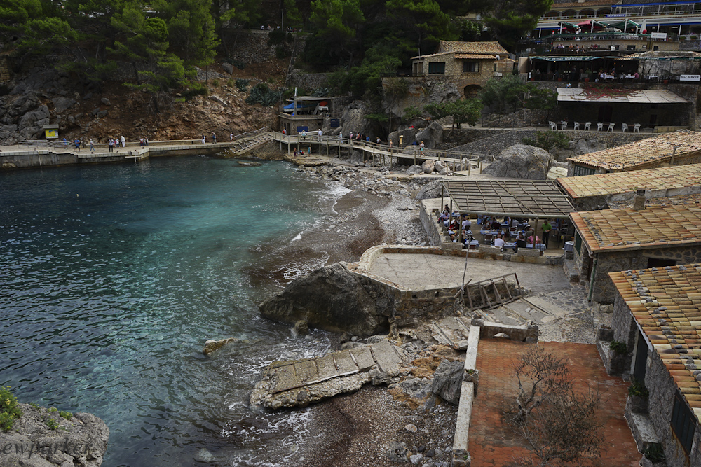
This is Sa Calobra – more of a port than a swimming beach.
Another thing I have learned from experience on this trip is that if the place you’re going has road signs – expect a lot of development when you get there. Certainly Mallorca is not a wild and undiscovered place. There have been people living on this island since the Phoenicians! Modern tourism began in the 1930s and really took off in the 1980s. The countryside, if you squint, can take on the look of long ago (squinting gets rid of the phone lines, the highways, the cars on those highways and the billboards). There is nature here in abundance, and certainly in the mountains, hiking along the trails, you are bound to find yourself closer to it than you will anywhere else, but let’s face it: Mallorca is a well-developed island. (Understand that “well” developed is intended in both the sense of quantity and quality. The trails through the mountains have trail heads with parking. Tourism is big business here – The Balearic Islands (Mallorca, Menorca and Ibiza) are the largest generators of foreign exchange in all of Spain – ahead of the Canary Islands and Madrid.

The walkway between Sa Calobra and the Torrent de Pareis
Sa Calobra is a good example of tourism developed. There is a boat that comes here from the Port of Sóller (a different city from Sóller). There are restaurants galore, though all self-serve buffets. But there are also services, provided by the municipality in the form of clean bathrooms, first aid station and even beds for hikers and paid parking.
Sa Calobra is another cove, but this one does not seem like a place for swimming – but rather for boats. The sign pointing to the water even says “port.” But from this place of great activity and milling tourists, you will also find the sign pointing to Torrent de Pareis. The walkway is well paved and even landscaped and the view is unforgettable – you’re near the bottom of the cliffs. Islands of stone dot the water below. My favorite islet had a beautifully shaped tree growing on top. The water was dark blue fading to a light blue on the horizon that melted right in with the overcast sky making you feel like you were on the edge of infinity.
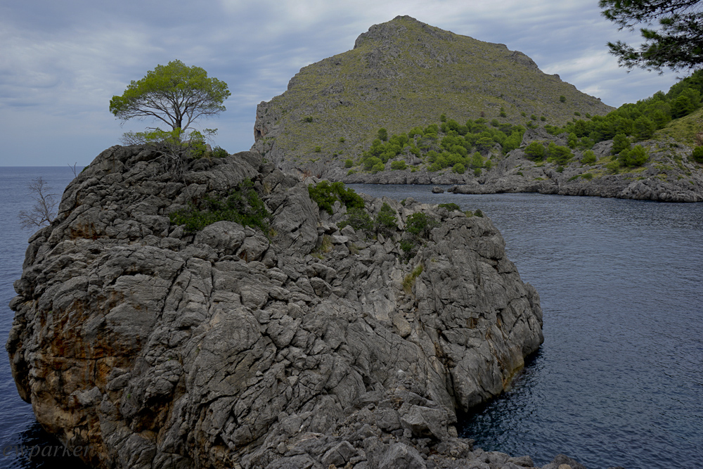
Love this tree – don’t you?
You follow the walkway around the mountains, even through a lighted tunnel and emerge on the edge of the torrent. The torrent is a river, named “the twins” because higher in the mountains two rivers join, one from the Blue Gorge which we passed along the way here and the other called the Lluch torrent, I assume originating near the monastery. The rivers flow together and down through a wide gorge to exit into the sea at Sa Calobra. The wide gorge makes this section very much like a river, with stony beaches and sand bars where the water is slow. It is very beautiful, even on an overcast day.
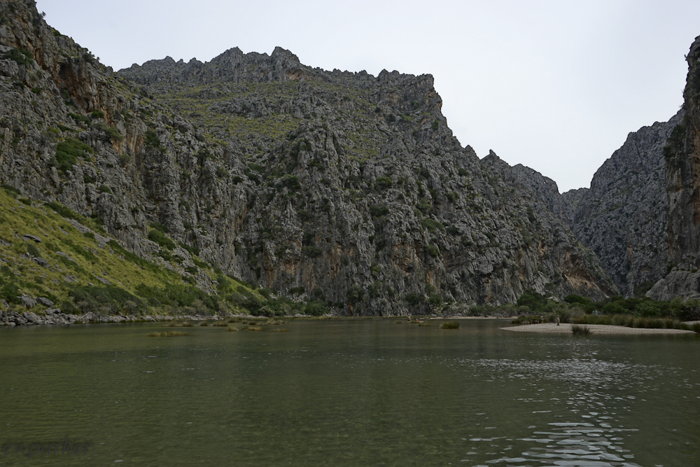
None of the pictures of the torrent captured how beautiful it is. The grey sky wasn’t helpful. Just try to imagine what those rocks and water would look like in the sunshine.
You definitely must come here when you visit Mallorca. Be sure to wear your swimming suit as the water is so inviting. You will also want to wear it so that you can explore back up the river away from the beach (and the crowds). Though I had water shoes on and a skort, the water was too deep in places for mere wading. Gerry was not at all dressed for this, though in this crowd his boxers could easily have passed for a swimsuit. Our day was also not the best for adventure – though I am sure a sunny day during the high season would be just perfect for it!
At this point we had to make a change of plans. Originally we had planned to leave this area in time to have lunch in a town called Caimari, but a phone call to check on the serving times, revealed that we had to have called between 11-12 for a lunch reservation. Instead we decided to head for Cap de Fomentor, the northern headland of the island.
Cap de Fomentor is quite a drive from where we were. First we had to back track along the entire road to Sa Calobra to find the main road between Sóller and Pollenca. Once there, we were again driving on the mountain roads. I was amazed as we drove along through the rock to see ancient olive trees, tenaciously clinging to both the rocks and life, looking for all the world as if they had been abandoned in some century past. Their trunks, gnarled and twisted, as big as a football player’s torso, sometimes burned out, sometimes broken, might have just a single, almost leafless branch stretched to the sky, pronouncing its survival yet. “Venerable old trees” was the phrase that would come to mind. The rocks sheltered other plant life, too. Delicate lichens painted the rocks, and moss found a root-hold in the dirt that collected in the cracks and dents. Scrubby plants, typical of rocky areas, were never abundant, and once below the tree line, there were pines. The scene was all black and white and green, occasionally burnt sienna (dead pine branches) would stand out, reminding me that it is fall at home.
The mountains end dramatically, their tailings stretching into the huge plain near Pollenca. We’re headed even further today – to the very end of the Fomentor peninsula. Leaving behind Pollenca and Port de Pollenca, we are back up in the rocky mountains. Eschewing the turn off for the Fomentor Beach we come upon a mirador, a lookout point, where we left the car to see what there was to see.

180 degree panorama shows the walkway here…
There was a lot to see – 360 degrees of a lot to see. And boy, were we high up! It was hard to breathe normally. Like being at the top of the world, everything was down, and far down. Walking along the path (at least 10 feet wide), I had to walk in the middle or as far away from the edge as I could, and I couldn’t look down and walk at the same time. It was too disorienting, too easy to misstep. The views were terrific. But so was the fear of falling. Parents holding small children near the edge was too much for us, and after getting our pictures, we returned to the car. I was able to get a 360 degree panorama … hopefully I will be able to post it here for you to see!
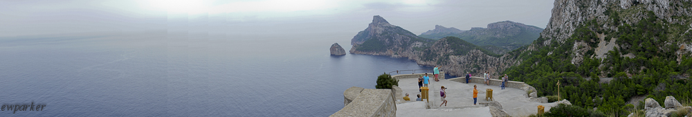
…and the other 180 degrees shows the headlands and the sea
When we finally arrived at Cap de Fomentor, we realized that this was not the place we thought we were going! Here was a lighthouse and across the straits we could see Menorca in the haze. It was actually a bit anticlimactic.

This is the road to Cap de Fomentor, from the lighthouse at the end looking back. That headland you see is the same one (from the other side) as the one you can see in the look out point pictures.
The place we thought we were going turned out to be a headland above the Fomentor Beach. On our last visit we had arrived there too late to walk down to the beach below. It was memorable because of the island we could see below us…here there was no island below.

View of Menorca out there on the horizon.
Having made it to Cap de Fomentor, we were done for the day and headed back to the hotel, about an hour and a half drive. Fortunately our return was on the superhighway – sixth gear all the way! This is probably our last foray into this part of the island as well. Tomorrow we plan to go east, beach exploring again.

From this height the water looks perfectly smooth!

You must be logged in to post a comment.